Bermuda Bus Routes & Stops
All bus routes in Bermuda originate from the central bus terminal at Hamilton City, reach out to different destinations within the island and return. The only exception is bus route #6 which operates between St. George's Town and St. David's Island at the eastern end.
From Hamilton City, some routes go towards the western parishes, while some towards eastern parishes. Few short routes, however, cover only the suburbs around Hamilton in the centrally located Pembroke parish. There are total of 11 bus routes in Bermuda and they are spread across
14 bus zones of approximately two miles each.
Western and Central Bus Routes
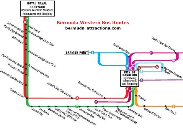
If you are traveling between Hamilton City and the western parishes like Warwick, Southampton, or Sandy's (including Royal Naval Dockyard), you can refer to the map below showing the Western Bus Routes of Bermuda.
The central routes (#4, 5 and 9) each covers a part of Pembroke parish around Hamilton. The route #2 covers a part of Paget Parish as well.
Western Bus Routes of Bermuda
As you can see in the map above, there are essentially two main bus routes (#7 and 8) that start from Hamilton City and go all the way up to the Dockyard (Kings Wharf port area) at the western tip of Bermuda.
Route #7 goes along the south shore (by South Road) and you get a wonderful view of the south shore beaches. Route #8 takes the Middle Road and you get nice views of the parish landscapes. Both these routes finally merge at Barnes Corner located near the western end of Southampton. It takes approximately 1 hour of travel between Hamilton City and the dockyard by bus.
Destinations served by Bus Route #7
(Hamilton to Dockyard)
Bermuda Underwater Exploration Institute (Hamilton),
Botanical Gardens / King Edward VII Hospital,
Coco Reef Resort,
Elbow Beach / Elbow Beach Hotel,
Coral Beach Club,
Warwick Long Bay Beach,
Horseshoe Bay Beach,
Fairmont Southampton Hotel,
Gibbs Hill Lighthouse,
The Reefs Resort,
Church Bay Beach,
Barnes Corner,
Bermuda Golf Academy,
Pompano Beach Club,
Hog Bay Park,
Port Royal Golf Club,
Rockaway ferry,
Somerset Bridge / Fort Scaur,
Cambridge Beaches / Somerset Long Bay,
Somerset Village,
Royal Naval Dockyard
Average running time between places (Bus Route #7)
Hamilton to Elbow Beach: 14 minutes
Hamilton to Warwick Long Bay: 22 minutes
Hamilton to Horseshoe Bay Beach: 25 minutes
Hamilton to Gibbs Hill Lighthouse: 29 minutes
Hamilton to Somerset: 53 minutes
Hamilton to Dockyard: 62 minutes
Dockyard to Somerset: 9 minutes
Dockyard to Barnes Corner: 28 minutes
Dockyard to Horseshoe Bay Beach: 37 minutes
Dockyard to Warwick Long Bay Beach: 40 minutes
Dockyard to Elbow Beach: 48 minutes
Dockyard to Hamilton City: 62 minutes
Destinations served by Bus Route #8
(Hamilton to Dockyard)
Bermuda Underwater Exploration Institute (Hamilton),
Belmont Hills Golf Course,
Paget Marsh,
Warwick Pond,
Riddel's Bay Golf Course,
Barnes Corner,
Bermuda Golf Academy,
Pompano Beach Club,
Hog Bay Park,
Port Royal Golf Club,
Rockaway ferry,
Somerset Bridge / Fort Scaur,
Cambridge Beaches / Somerset Long Bay,
Somerset Village,
Royal Naval Dockyard
Average running time between places (Bus Route #8)
Hamilton to Cobbs Hill: 15 minutes
Hamilton to Cedar Hill: 23 minutes
Hamilton to Barnes Corner: 34 minutes
Hamilton to Somerset: 53 minutes
Hamilton to Dockyard: 62 minutes
NOTE: Some services on these two routes (#7 and #8) do not serve the dockyard and instead terminate at Barne's Corner and return. A display in front of the bus indicates the final destination.
Destinations served by Bus Route #2
(Hamilton to Ord Road, Paget)
Bermuda Underwater Exploration Institute (Hamilton),
Botanical Gardens / King Edward VII Hospital,
Coco Reef Resort,
Elbow Beach / Elbow Beach Hotel,
Ord Road
Destinations served by Bus Route #4
The short route #4 originates at Hamilton Central Bus Terminal, goes up to Spanish Point in Pembroke and returns. Some services of this route take the North Shore Road (the upper blue line of the route #4, as shown in the map above), while the rest go via St John's Road (the lower blue line of the route).
Destinations served by Bus Route #5
This is the shortest of all routes. It goes from Hamilton to Pond Hill in Pembroke via Glebe Road (10 minutes one-way). This route is used mostly by local residents.
Destinations served by Bus Route #9
This is a curricular route in Hamilton/Pembroke area and covers Bermuda National Stadium, Cedar Park, Palmetto Road etc. The average circular run time of this route is 10 minutes in either direction.
Eastern Bus Routes
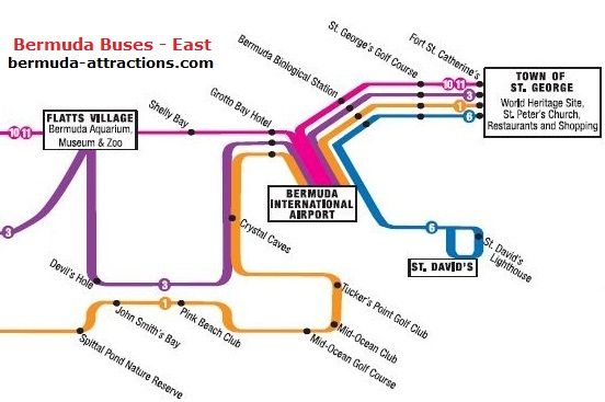
If you are traveling between Hamilton City and the eastern parishes like Devonshire, Smith's Parish, Hamilton Parish or St George's, the bus routes in the map below will come into play.
Eastern Bus Routes of Bermuda
As you can see in the route map above, bus routes #1, 3, 10 and 11 operate from Hamilton City right up to St. George's. The only difference is that bus routes #1 and 3 operate through the lower part (Smith's parish) while #10 and 11 operate through the upper part of Bermuda (North Shore and Hamilton Parish).
If you are heading directly to St. George's from Hamilton, then routes #10 and #11 will be faster. It takes roughly an hour to travel between Hamilton City and St. George's by bus.
Destinations served by bus #1
(Hamilton to St. George)
BUEI (Bermuda Underwater Exploration Institute, Hamilton),
King Edward VII Hospital,
Botanical Garden,
Spittal Pond,
John Smith's Bay Beach,
Pink Beach Club / The Loren at Pink Beach Hotel,
Mid Ocean Golf Club,
Tucker's Point Golf Club,
Crystal & Fantasy Caves,
Swizzle Inn / Blue Hole Park / Grotto Bay Beach Hotel,
Bermuda International Airport,
St. George's Town.
Average running time between places (Bus Route #1)
Hamilton to Hospital / Botanical Gardens: 7 minutes
Hamilton to Collector's Hill: 16 minutes
Hamilton to John Smith's Bay: 25 minutes
Hamilton to Mid Ocean Club: 32 minutes
Hamilton to Tucker's Point Club: 37 minutes
Hamilton to Crystal Caves: 39 minutes
Hamilton to Swizzle Inn / Grotto Bay: 42 minutes
Hamilton to Airport: 47 minutes
Hamilton to St. George: 65 minutes
Destinations served by bus #3
(Hamilton to St. George)
Arboretum,
Flatts Village,
Bermuda Aquarium, Museum & Zoo,
Crystal & Fantasy Caves,
Swizzle Inn / Blue Hole Park / Grotto Bay Beach Hotel,
Bermuda International Airport,
St. George's Town.
Average running time between places (Bus Route #3)
Hamilton to Arboretum: 10 minutes
Hamilton to Aquarium: 20 minutes
Hamilton to Crystal Caves: 38 minutes
Hamilton to Swizzle Inn / Grotto Bay: 40 minutes
Hamilton to International Airport: 45 minutes
Hamilton to St. George: 65 minutes
Destinations served by bus #10 and 11
(Hamilton to St. George)
WER Joell Tennis Stadium,
National Sports Center,
Ocean View Golf Course,
FlattsVillage,
Bermuda Aquarium, Museum & Zoo,
Shelly Bay Beach,
Swizzle Inn / Blue Hole Park / Grotto Bay Beach Hotel,
Bermuda International Airport,
St. George's Town.
Average running time between places (Bus Route #10 and 11)
Hamilton to WER Joell Tennis Stadium: 5 minutes
Hamilton to National Sports Center: 10 minutes
Hamilton to Ocean View Golf Course: 15 minutes
Hamilton to Aquarium: 20 minutes
Hamilton to Shelly Bay Beach: 25 minutes
Hamilton to Swizzle Inn / Blue Hole Park / Grotto Bay: 30 minutes
Hamilton to International Airport: 35 minutes
Hamilton to St. George's: 50 minutes
Destinations served by Bus Route #6
(St. George to St. Davids)
This route operates between St. George's Town and St. David's. It serves Carter House, St. Davids Light House etc. Some services also serve the Clear Water Beach. One way run time (St. George to St. Davids) is 25 minutes.
Map of Bermuda Bus Stops on Routes
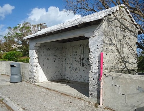
Bus stops in Bermuda are marked by a pole that rises from the ground. A pole may be pink or blue in color. A pink pole means the arriving bus is heading towards Hamilton City Bus Terminal. A Blue pole means the bus is going outward from Hamilton City.
A Bus Stop in Bermuda with a pink pole
The final destination of the route (Hamilton or some other place) is displayed in front of the bus. So, choose the pole correctly based on your direction of travel.
Note that in Bermuda, buses and all road transports travel on the left-side of the roads. Since the pole color determines the direction of the bus, a pink and blue pole will never be on the same side of a road.
Also, on roads with bi-directional traffic, you may not always find bus stops (poles) on both sides of the road. So, although you may find a bus stop at some point on a route to go towards Hamilton City, you may not find one to go the other direction, and vice versa. Some bus stops in Bermuda have kiosks or shelters in addition to a pole, but not all.
The map below shows the bus stops on each bus route. Zoom on a section to see the details. Pink and Blue Pole bus stops are marked separately, so that you know which way the bus is going. Click/tap on a bus stop to get more details such as description or nearest landmark, location, distance to Hamilton Ferry Terminal, etc.
Thanks to Henry J Kindervatter, a reader and patron of this website for having created this excellent Bus Stop Map of Bermuda, which has been a long sought after one. The map additionally shows locations of restrooms, grocery stores, etc.
|
 By Raj Bhattacharya By Raj Bhattacharya
Raj, a seasoned travel writer and Bermuda destination expert, has extensive global travel experience. This website reflects his profound insights, garnered over nearly two decades of dedicated findings and research on the island. Raj has assisted countless Bermuda-bound visitors by providing direct, personalized responses to their queries and imparting his wealth of knowledge through this platform. This site serves as an indispensable guide for those seeking informed and reliable insights into Bermuda's treasures.
|
Related Articles
|
Visitors' Reviews and Comments
Mari C (January 2016)
I want to buy a booklet of tickets but not sure if I need 3 zone or 14. zone. For instance, after taking the ferry, we will travel from St George or Hamilton to Tom Moore's jungle. How can we tell how many zones that is? Is there a place that tells us? Thank you for your help.
Raj (bermuda-attractions.com) January 2016
When you pick up the time table from a Visitors Information Center, it also shows you the zone boundaries on the backside. However that only gives you a rough idea and you may not always know clearly the number of zones between two exact points. Usually if the travel is short and limited within about 2 miles, then it is a 3-zone travel, otherwise 14-zone. So better to ask at the counter while buying the ticket booklets, and the staff at the counter can help you with ticket booklet depending on your travel plan. With that said, your travel plan will require 14-zone tickets (including in the ferry). If you plan to travel around in the island, it's wise to buy book of tickets for 14-zones instead of restricting the travels for few dollars.
V Stern (July 2014)
I'm bringing my 11 year old granddaughter to Bermuda next week. Arriving at Kings Wharf Dock. Day 1 planning to take ferry to St Georges, then St Peter's, Unfinished Cathedral, Caves and Aquarium. Can I get bus to get to all these sites and then take ferry back to boat from Hamilton at end of day? Which buses and how do I find them?
Day 2, hoping to take ferry to Hamilton and walk or take buses to Cathedral, Post Office, Government buildings and Underwater Exploration Center - as well as lunch at the pub and a visit to the English Shop. Where do I find buses, or can we walk to everything. This is a big trip for us and I want to be prepared to get around and not waste time looking for buses etc. Thank you so very much.
Raj (bermuda-attractions.com) July 2014
Within St. George, best is to walk. There is minibus service to few places though (available from Kings Square area). From St George take bus #1, 3, 10, or 11 to the caves. Then bus #10 or 11 to Aquarium, then continue on same buses (#10,11) to Hamilton city. Take the blue route ferry back to dockyard. Within Hamilton, you can walk around and visit the places.
Wilma Kamps (July 2014)
Hello, I was in Bermuda in 1986 and had strawberry shortcake every morning at the Fourways. Yummy! In October 2015 I will be in Bermuda for 3 days, sailing there on the Carnival Splendor, docked at King's Wharf. Can I take a bus from there to the Fourways? It's at #1 Middle Road. Thanks in advance for your help.
Raj (bermuda-attractions.com) July 2014
Hi, you can take bus #8 from the dockyard to Fourways Inn.
|